VEDAIR Construction
Continuous Improvement
VEDAIR's roots are deeply seeded in Continuous Improvement, Good Manufacturing Processes, and Kaizen Philosophy. We are never satisfied with our commitment to Safe, Efficient, Practical methods of operation. With this new exciting technology you will see your operations from angles never seen before. This allows you to adapt and change the way you work to be the best and safest you possibly can.
WE DO NOT JUST PREACH SAFETY, WE CHOOSE TO BE SAFE
SAFETY HAS NEVER BEEN SO VISIBLE
The number one goal of every company should be ZERO INCIDENTS. Achieving this goal takes the alignment of many factors to ensure everyone goes home the same way they arrived. According to PwC Drone Powered Solutions, the diminishment of threatening accidents on the job site can be reduced by up to 90% by employing drone technology into the site management. The ability to see the construction site from multiple angles in real time is one factor that is revolutionizing construction site safety. New views, quick measurements, and 3D imaging is now minutes away and can assist in all of these facets.
3D mapping of hazards such as trenching protection, trespassing detection and prevention
Pre planning tools for accurate estimation of contract pricing
Count structural members, foundation penetrations, and square footage in seconds
Map safe Egress and Entrance paths for current and future operations
Create visual aids for traffic direction and critical lift safety areas that can be disseminated rapidly.
Investment and Progress Monitoring
During the life of a construction project the amount of claims due to contract changes and conformity can reach millions of dollars. With regular aerial documentation of the construction site progress, both clients and contractors can defend themselves against liability. Progress monitoring is a must at all construction sites and can be accomplished easily on a daily, weekly, or monthly basis and with our cloud based services you are assured that your data is safe, secure and readily available on all types of media from anywhere connectivity is possible.
MERGING VIRTUAL DESIGN WITH REALITY
VEDAIR uses the latest software programming to turn aerial data into useful deliverables. With the integration of DroneDeploy software we can create accurate mapping products for your site or integrate our data into your current design workflows. CAD drawings can overlay direction onto real time aerial photos giving project managers visibility to vital elements of the construction site. Quickly obtain highly-accurate point clouds compatible with BIM software to create real planning documents and site safety procedures.
Incorporate 3D modeling into pre construction site mapping to establish safe entry and egress as well as crane reach and utility infrastructure.
Make quick assessments of concrete and pipe work
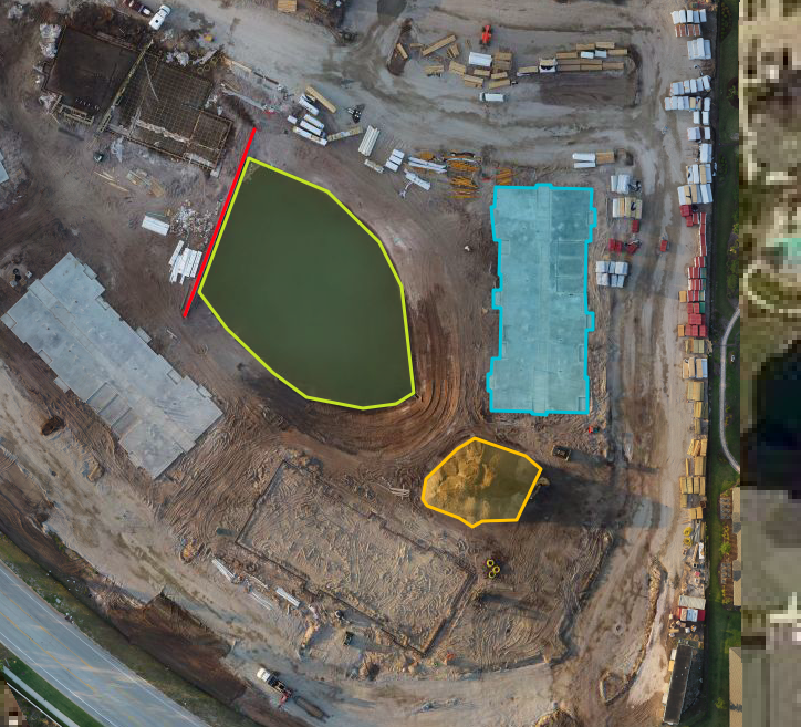
Monitor earthwork on site and quickly calculate volumes for cut and fill
Measure any component including structure, trenching, perimeter encroachment
Emergency Evacuation planning and site safety areas
LIVE 4K VIDEO FEED
With safety always on our mind we strive to keep the site owners informed of whats happening.
We create an account through either our secure site or a social media platform and link straight to any authorized user.
The video material is also saved for easy download
Let our marketing wizards produce material for advertising and or your website news feed.


